Difference between revisions of "HowTo Setup The NST System With A GPS (gpsd)"
(Created page with '= Why Connect A GPS? = The primary reason you would connect a GPS to a NST system is to geolocate systems based on WIFI transmissions. * You connect a GPS to your NST system. *…') |
|||
| Line 11: | Line 11: | ||
= Selecting GPS Hardware = | = Selecting GPS Hardware = | ||
| + | It can be tricky in selecting GPS hardware that will be compatible with your NST system. Basically, you want to look for: | ||
| − | + | * GPS hardware which can put out the NMEA data such as the v2.1 GSA format. | |
| + | * The necessary hardware and drivers to physically connect the GPS hardware to your NST system. | ||
| + | The [http://gpsd.berlios.de/hardware.html Compatible GPSes] list at the [http://gpsd.berlios.de/|gpsd web site] is probably a good place to start. However, GPS models change so frequently, you may find yourself searching for reader comments and feedback at on-line stores. | ||
| + | |||
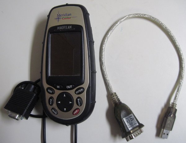
| + | Here is a photo of a Magellan Meridian Color GPS with its RS-232 adapter and a serial to USB adapter which are known to work: | ||
| + | |||
| + | [[File:magellan-meridan-color.jpg|center|frame|Magellan Meridian Color GPS and serial to USB adapter]] | ||
| + | |||
| + | Unfortunately, the serial to USB adapter was purchased a long time ago (probably from http://www.cyberguys.com/). The only labeling on the serial to USB adapter shown above is a model number of ''GUC232''. | ||
| + | |||
| + | |||
| + | = Testing GPS Connection = | ||
| + | |||
| + | == Hardware Setup == | ||
| + | |||
| + | == Listing Serial Devices == | ||
| + | |||
| + | == Using '''gtkterm''' to View GPS Data == | ||
= Setting Up '''gpsd''' = | = Setting Up '''gpsd''' = | ||
| + | |||
| + | == Editing: ''/etc/sysconfig/gpsd.conf'' == | ||
| + | |||
| + | == Starting The '''gpsd''' Service == | ||
= Testing '''gpsd''' Configuration = | = Testing '''gpsd''' Configuration = | ||
| + | |||
| + | == Using '''telnet''' == | ||
| + | |||
| + | == Using ''xgps'' == | ||
Revision as of 11:27, 23 September 2010
Contents
Why Connect A GPS?
The primary reason you would connect a GPS to a NST system is to geolocate systems based on WIFI transmissions.
- You connect a GPS to your NST system.
- You run the kismet process which will scan for systems using WIFI communications.
- You then view the locations of discovered WIFI systems in Google Earth.
This page provides information on getting a GPS properly connected to a NST system. For details on using kismet after you have your GPS connected, see: "HowTo Geolocate kismet Data".
Selecting GPS Hardware
It can be tricky in selecting GPS hardware that will be compatible with your NST system. Basically, you want to look for:
- GPS hardware which can put out the NMEA data such as the v2.1 GSA format.
- The necessary hardware and drivers to physically connect the GPS hardware to your NST system.
The Compatible GPSes list at the web site is probably a good place to start. However, GPS models change so frequently, you may find yourself searching for reader comments and feedback at on-line stores.
Here is a photo of a Magellan Meridian Color GPS with its RS-232 adapter and a serial to USB adapter which are known to work:
Unfortunately, the serial to USB adapter was purchased a long time ago (probably from http://www.cyberguys.com/). The only labeling on the serial to USB adapter shown above is a model number of GUC232.
